Some of the numbers presented in this website may not be the most recent available
globalshift.co.uk - copyright © 2009 to 2026; All rights reserved

Brief history of the country
Suriname (the Republic of Suriname) is bordered by French Guiana (east), Guyana (west) and Brazil (south) with the Atlantic on its north coast. The country's name was changed from Surinam in 1978.
The Arawaks arrived in the Guianas before 3000 BC, followed by Caribs and inland tribes. Columbus sighted the region in 1498 and by the 17th century Suriname was part of a group of Dutch plantation colonies. Disputes between the Dutch and English led, in 1667, to a settlement in which the Dutch kept Suriname in return for New Amsterdam (now New York).
Plantations relied on African slaves. Some slaves escaped and interbred with inland tribes to form the Maroons who were eventually given trade rights. Slavery was abolished in 1863, slowly replaced by contract labourers from the Far East, especially from India and China.
During World War 2 the USA protected the bauxite mines and after the war, in 1954, Suriname became a country of the Kingdom of the Netherlands. iI 1975 independence was granted and a large part of the population emigrated. The economy was left with a corrupt political system dependent on Dutch aid.
A series of military coups and counter-coups began in the 1980s and the political situation remains fluid. The economy is dominated by bauxite and agriculture but oil will become a significant source of revenue towards the end of the 2020s.
Oil and gas summary
Suriname is underlain by the Guiana Shield; a Precambrian block that forms the major part of the northern highlands and coast. Most of the offshore is a continuation of this block, known as the Demerara Rise. There is limited sedimentary cover onshore with sediments only thickening offshore
Onshore the country can be divided into two main geographic regions. The northern, lowland coastal area is where most of the population lives. The southern tropical rainforest and savanna is sparsely populated but covers about 80% of the land.
Heavy oil has been produced since 1983 from the Tamaredjo field, in an onshore part of the Guyana basin. Other small fields in the neighbourhood have allowed the country to expand output but a peak has now probably been reached.
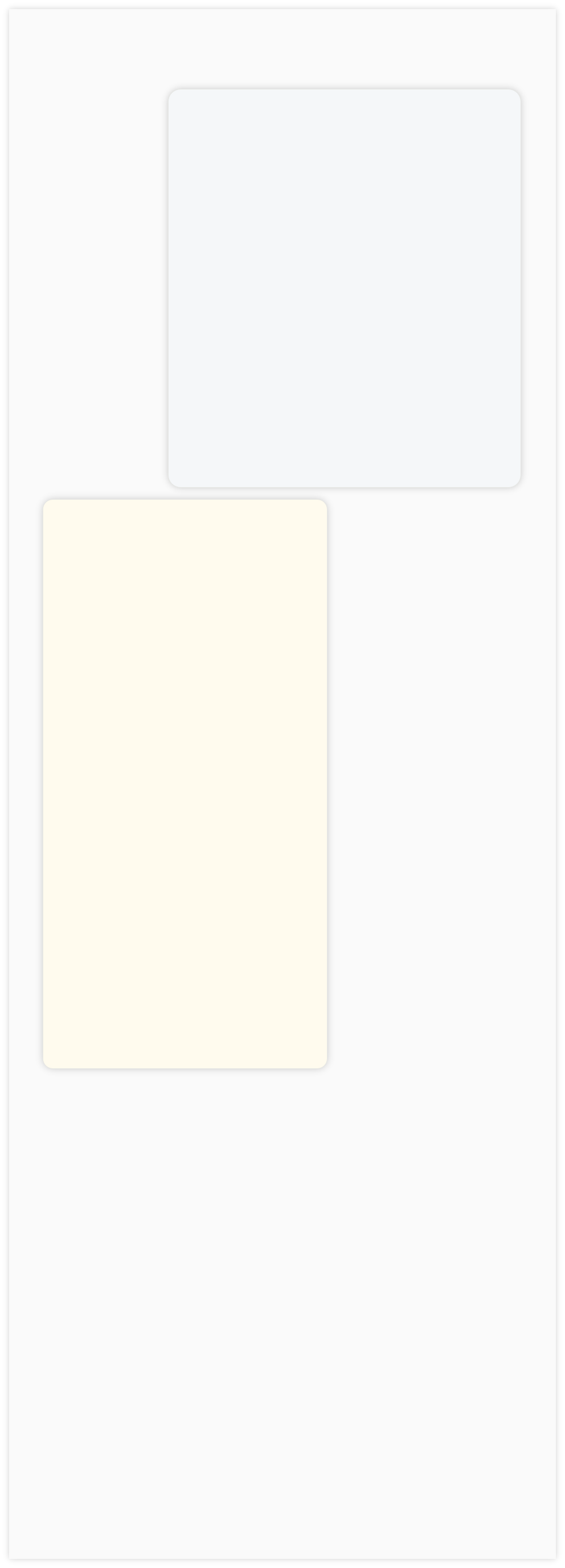
The country produces no offshore oil with drilling offshore on the Rise failing to find hydrocarbons. A deep water well, Zaedyus-1, was drilled in 2011 in French Guiana and discovered a significant oil column in two turbidite fans. It was a pivotal well unlocking a new productive area along the northeast coast of South America, with fields analogous to those in West Africa.
Since 2020 a number of discoveries have been made in deep waters especially in Block 58 by TotalEnergies. Significant production is expected to start towards the end of the decade. Suriname produces and uses no gas but gas markets and export capacity will probably be developed along with the oil.
The southernmost borders of the country remain disputed but the maritime boundary with Guyana was arbitrated by the UN Convention on the Law of the Sea in 2007 allowing drilling to proceed.

SURINAME
Map and National Flag


SOUTH AMERICA
Catch of the day
South America


Capital
Population
Land area (sq kms)
Oil prod (000s b/d)
Gas prod (bcm/yr)
Oil cons (000s b/d)
Gas cons (bcm/yr)
Paramaribo
0.52 mm
163,820
15.5
None
15
None
Government
Suriname is a representative democratic republic.
The President, elected for a 5-year term by the National Assembly, is head of state. The president appoints a 16-member cabinet.
The legislative branch consists of a 51-member unicameral National (People’s) Assembly elected for a 5-year term.
The Ministry of Natural Resources sets policy for the exploitation of oil and gas resources in the country.
Staatsolie Maatschappij Suriname NV is the state-owned national company founded in 1980. It is involved in exploration, production, refining, marketing and transportation of oil products, whilst monitoring the operations of foreign oil and gas companies in Suriname.
SURINAME: OFFSHORE LICENCES
Globalshift.co.uk (source: Oil and Gas Financial Journal)