
Some of the numbers presented in this website may not be the most recent available
globalshift.co.uk - copyright © 2009 to 2026; All rights reserved

Brief history of the territory (France)
French Guiana (officially Guyane) is an overseas department of France on the north Atlantic coast of South America. It borders Brazil to the south and east and Suriname to the west. In colonial times there were 5 Guianas; Spanish (now Guayana in Venezuela); British (now Guyana); Dutch (now Suriname) and; Portuguese (now Amapa in Brazil).
Originally inhabited by Native Americans, it was colonised by the French as a penal colony (including the infamous Devil’s Island) in 1763. The French also introduced African slaves and, later, Asian labourers.
The region was invaded and adopted into Portugal’s Empire in 1809 but returned to France in the Treaty of Paris in 1814. After several border disputes with Brazil it was finally unified in 1946 and became an overseas department of France. Its last penal colony closed in 1953.
French Guiana’s economy is dependent on France for subsidies, trade, and goods and is dominated by the presence of the Guiana Space Centre - the European Space Agency's main launch site.
Traditional industries such as fishing, gold mining and timber, provide the bulk of exports. Illegal gold mining and immigration are recurring problems.
Oil and gas summary
French Guiana is underlain by the Guiana Shield, a Precambrian block that forms the major part of the northern highlands and coast. Most of the offshore is a continuation of this block, known as the Demerara Rise. There is limited sedimentary cover onshore with sediments only thickening offshore, especially on the Rise’s eastern slope where Atlantic rifting began.
French Guiana thus has no onshore potential for oil or gas. Limited drilling offshore on the Rise also failed to find hydrocarbons. However, a deep water well, Zaedyus-1, was drilled in 2011 on the eastern slope and discovered a significant oil column in two turbidite fans.
It was a pivotal well, thought to have unlocked a new productive area along the northeast coast, with fields analogous to those in West Africa.
Subsequent drilling has failed to follow up on this success and the whole area remains high risk with a shortage of sufficiently large trapping possibilities. The territory therefore has no commercial oil or gas resources and Globalshift does not forecast production, at least in the short and medium term.

GUYANE (FRENCH GUIANA)
Map and National Flag


SOUTH AMERICA
Clown fish
South America


Capital
Population
Land area (sq kms)
Oil prod (000s b/d)
Gas prod (bcm/yr)
Oil cons (000s b/d)
Gas cons (bcm/yr)
Cayenne
0.22 mm
83,534
None
None
7
None
Government
Like Martinique and Guadeloupe, French Guiana is a is a Department of France.
The head of state is the President of France who appoints a prefect as representative to head the local government of an elected council (sending 2 deputies to the French National Assembly).
As an integral part of France it is in the EU and Eurozone with France responsible for any energy resources.
Geology and History of Exploration
French Guiana is underlain by the Guiana Shield, one of 3 cratons making up the South American Plate. It is a Precambrian block that forms the major part of the northern highlands and coast in French Guiana, Suriname, Guyana, and parts of Venezuela and Brazil.
The rocks of the Guiana Shield consist of meta-sediments and meta-volcanics with limited sedimentary cover. This cover thickens near the coast and offshore into the Guyana-Suriname Basin.
In Jurassic and early Cretaceous times, at the northwestern edge of the Shield off French Guiana and part of Suriname, an area called the Demerara Rise formed the southern extremity of the Central Atlantic Rift and Ocean. Sedimentation here was in an inner shelf environment with continental influxes. In the Early Cretaceous shallow marine to open marine deposition began in response to the opening of the Atlantic Ocean.
The Atlantic Ocean opened east of the Demerara Rise during the Early Cretaceous. Here the continental shelf is narrow with water depths rapidly deepening to 3,000m. Drilling commenced in 2011 in the hope of finding analogous fields to those discovered in West Africa on the other side of the Atlantic Rift.
Wells identified oil-bearing turbidite fans of Cretaceous age but subsequent drilling has failed to follow up on this success and the whole area remains high risk with a shortage of sufficiently large trapping possibilities.
Globalshift predicts older Mesozoic troughs below the shelf but these have not been drilled and cannot be inferred due to the poor quality of seismic data at depth.
History - The first wells drilled offshore French Guiana were in 1975 and 1978 on the Demerara Rise. Both were dry holes. After a long break Tullow acquired the Guyane Maritime licence covering an extensive offshore area along the continental slope. This was part of its acquisition of Hardman Resources in 2007.
In 2009, Tullow farmed out a substantial interest to Shell and Total, and a further interest to Shell and operatorship in 2010. A 2,500 sq km 3D seismic programme began in September 2009 targeting the Eastern Slope section of the licence where leads matching the Jubilee field in Ghana were identified. The first well, Zaedyus-1, was commenced in March 2011.
This well proved that similarities with West Africa were present. It encountered 72m of net oil pay in high quality reservoir intervals - a turbidite sand called the Cingulata sand system. However a further four wells (3 appraisal and 1 exploration) in 2012 and 2013 were unsuccessful. A further dry well was drilled in 2019.
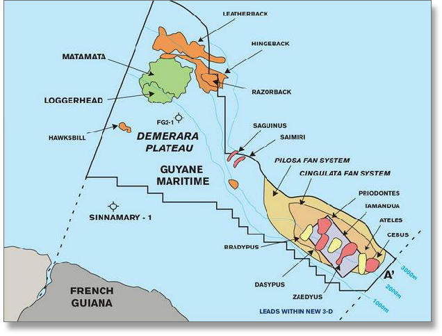
FRENCH GUIANA: OFFSHORE STRUCTURES
Globalshift.co.uk (source: Northern Petroleum)