
Some of the numbers presented in this website may not be the most recent available
globalshift.co.uk - copyright © 2009 to 2026; All rights reserved


Brief history of the country
Hungary is land-locked, bordered by Slovakia and Ukraine (north), Romania (east), Serbia and Croatia (south) and Slovenia and Austria (west). It almost entirely overlies most of the Pannonian Basin.
Inhabited by Celts and Avars, the Romans conquered the area after 35 BC. When Rome fell in 576 AD the Avars created a Khanate, replaced by empires of East Francia, Bulgaria and Great Moravia from 796. The Magyars then displaced the Avars, establishing a regional kingdom.
In 1241 a Mongol invasion devastated the country but it rapidly recovered and expanded once again. However, after 1490 it was overrun by the Ottomans and divided into Habsburg and Ottoman Slav areas. The Ottomans had been expelled by 1718.
The short-lived Hungarian Revolution in 1848 and a weaker Austria led the Austro-Hungarian Empire to be formed in 1867 with a dual monarchy and the economy was then modernised.
After defeat in World War 1, reduced borders were established in 1920. In World War 2 Hungary sided with Germany, hoping to expand again but after defeat the country became a communist dictatorship.
Soviets quelled an uprising in 1956 and Hungary finally opened its border with Austria in 1989, triggering collapse of the Eastern Bloc. It became a democracy and has an economy that grew rapidly after admission to the EU.
Oil and gas summary
Hungary is geographically divided into 3 regions by the Danube and Tisza rivers (Transdanubia, Tiszántúl and Duna-Tisza köze). The country has been land-locked since 1920 having lost its only seaport (Fiume, now Rijeka) to Croatia.
Transdanubia stretches west from the centre toward Austria and is a hilly region including the eastern Alps with the highest point at 882m.
Duna-Tisza köze and Tiszántúl form the Great Hungarian Plain which stretches across most of the eastern and southeastern areas of the country. To the north of the Plain are the foothills of the Carpathian Mountains in a wide band near the Slovakian border. Here Kékes, at 1,014m, is the tallest mountain in Hungary.
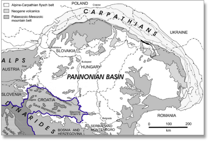
The whole of Hungary south of the Carpathians is underlain by a depression known as the Pannonian Basin. Hungarian oil production began in 1937 from this basin. Output grew to a maximum in 1984 from a large number of small and complex fields including significant volumes of natural gas liquids from the more widespread gas fields.
Hungary was an important non-associated gas producer from the Pannonian Basin but gas output has also been declining since 1985 although Globalshift expects that gas from shale could slow this decline and even reverse it in the 2030s. Its conventional fields are now largely depleted. Minor satellite accumulations occasionally come onstream.

HUNGARY
Map and National Flag


BUDAPEST
The Parliament Building
Eastern Europe


Capital
Population
Land area (sq kms)
Oil prod (000s b/d)
Gas prod (bcm/yr)
Oil cons (000s b/d)
Gas cons (bcm/yr)
Budapest
10 mm
93,028
18
1.9
132
8.5
Government
Hungary is a parliamentary democratic republic. Members of the unicameral parliament are elected to the 199-member National Assembly every 4 years.
The president is head of state with a ceremonial role, elected by the National Assembly every 5 years. The Prime Minister, also elected by the Assembly, is head of government, selecting cabinet ministers. Hungary joined the EU in 2004.
The Ministry for National Development oversees the oil and gas industry in Hungary.
MOL Group, established in 1991 as successor to the National Oil and Gas Trust (1957), is a multinational oil and gas company. Privatised in 1995, the largest shareholder is the Hungarian state.
MOL is vertically integrated, active in every area of the oil and gas industry with operations in over 40 countries.


HUNGARY: TECTONIC ELEMENTS
Globalshift.co.uk (source: Croatian Hydrocarbon Agency)