
Some of the numbers presented in this website may not be the most recent available
globalshift.co.uk - copyright © 2009 to 2026; All rights reserved


Brief history of the country
Austria (the Republic of Austria), is a land-locked country bordered by Czechia and Germany (north), Hungary and Slovakia (east), Slovenia and Italy (south) and Switzerland and Liechtenstein (west).
Austria was occupied by Celts of the kingdom of Noricum before being included in the Roman Empire in 100 AD. After repeated invasions it was incorporated into East Francia in 788 AD under the Babenbergs. Elevated to a duchy, the Babenberg line ended in 1246.
It was taken by the Habsburgs in 1276 who expanded into many parts of Europe. From 1438 all but one emperor of the Holy Roman Empire was a Habsburg. The Napoleonic wars saw the end of this empire in 1804 and in 1815 it became part of the German Confederation. Defeated by Prussia in 1866, the empire was then reformed into Austria-Hungary.
In 1914 the Austro-Hungarian Empire declared war on Serbia, triggering the 1st World War, which ultimately led to the Empire’s dissolution. In 1919 it became the Republic of Austria after being forbidden to unite with Germany. However, it was annexed by the Nazis in 1938 and fought with them in World War 2.
At the end of the war the Allies took over until 1955 when Austria became independent again, declaring neutrality. It now has a diverse economy with a significant tourist sector.
Oil and gas summary
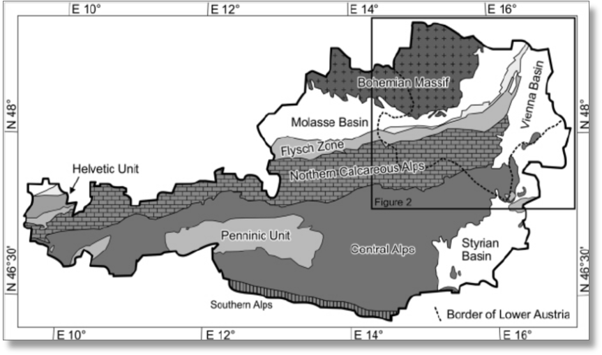
Land-locked Austria is mountainous, lying within the Alps with only 32% below 500m. Its highest point is Grossglockner, east of the Brenner Pass at 3,798m.
The Central Eastern Alps, Northern Limestone Alps and Southern Limestone Alps are all partly in Austria. The Austrian foothills lie at the base of the Alps in the north and the Carpathian foothills lie in the east. The Austrian granite plateau (Bohemian Massif) is located in the north central area adjacent to the Czech Republic.
The Vienna basin in the northeast covers around 4% of the country and is the area where most the country’s oil and gas is located.
Austrian oil production began in 1934 from the Vienna Basin and later in 1956 from the Molasse Basin between the Northern Limestone Alps and the Bohemian Massif. Output peaked in 1955, the bulk of which came from Austria’s largest field, Matzen in the Vienna Basin.
New discoveries are occasionally made but Globalshift expects that these, along with intensive enhanced oil recovery technologies, will be only sufficient to slow output decline.
Austria’s old fields deliver associated gas whilst some non-associated gas is also produced. However, these fields are nearing the end of their life. New discoveries and better technologies occasionally reverse decline for a period but overall output has been steadily falling.

AUSTRIA
Map and National Flag


VIENNA
View down the Graben
Southern Europe


Capital
Population
Land area (sq kms)
Oil prod (000s b/d)
Gas prod (bcm/yr)
Oil cons (000s b/d)
Gas cons (bcm/yr)
Vienna
8.4 mm
83,879
17.5
1.75
261
7.8
Government
Austria is a federal democratic republic. The head of state is the directly elected President.
The Chancellor (chairman of government) is appointed by the President. Parliament is bicameral.
The elected 183-member Nationalrat (National Council) is the dominant legislative chamber.
The upper house of parliament, the 61-member Bundesrat (Federal Council) has members who are elected by state legislatures. It has a limited right of veto. Austria joined the EU in 1995.
The oil industry is overseen by the Federal Ministry of Science, Research and Economy.
Österreichischen Mineralölverwaltung Aktiengesellschaft (OMV) began as the state-owned oil and gas company in 1956 and is now a multi-national corporation. It began to privatise in 1987.


AUSTRIA: TECTONIC SETTING
Globalshift.co.uk (source: Research Gate)