
Some of the numbers presented in this website may not be the most recent available
globalshift.co.uk - copyright © 2009 to 2026; All rights reserved


WEST AFRICA
Goat herder
Brief history of the country
Sierra Leone (the Republic of Sierra Leone) borders Guinea (north and east), Liberia (southeast), and the Atlantic Ocean (southwest).
Sierra Leone has been inhabited for 2,500 years. Settlements on the coast are recorded from around 1000 AD, which were protected by dense forest from conquest by African empires in the east. Two tribes dominated, the Temne in the north and the Mende in the southeast.
In 1462 the Portuguese arrived followed by other Europeans who used the region as a transit point for slaves. In 1787 the British Sierra Leone Company began to resettle freed slaves from North America. The newcomers imported the Krio culture and language and Freetown became a Crown Colony in 1808 from where British West Africa was administered.
In 1896 the UK annexed the inland region as the Sierra Leone Protectorate. Tensions with local chiefs led to the Hut Tax war of 1898 in which the Temne and Mende were defeated. Resistance continued with independence finally achieved in 1961.
Repeated coups from 1967 allied to corruption and mismanagement of resources led to a devastating civil war from 1991, finally ending in 2002 after the UK intervened. Sierra Leone now relies on mining but many of its people live in poverty. In 2014 Ebola seriously damaged economic recovery.
Oil and gas summary
Sierra Leone has 4 geographical regions. In eastern Sierra Leone the plateau is interspersed with high mountains, where the highest point, Mount Bintumani, reaches 1,948m.
The centre of the country is lowland plains, containing forests, bush and farmland. The south is rain-forested plains and farmland. In the southwest the coast has mangroves swamp where Freetown sits on a peninsula next to the world's third largest natural harbour.
Sierra Leone currently has no oil or gas production, either onshore or offshore. Offshore lies the Liberian Basin. The commencement of deep water drilling here in 2009 was driven by the identification of a new Cretaceous fan play along the West African transform margin in this basin. Turonian sands, similar to oil-bearing reservoirs in Ghana have been discovered.
Oil production is expected by Globalshift to begin within a decade with associated gas very likely to be exploited as well, for use in new local industries.
West Africa


SIERRA LEONE
Map and National Flag


Capital
Population
Land area (sq kms)
Oil prod (000s b/d)
Gas prod (bcm/yr)
Oil cons (000s b/d)
Gas cons (bcm/yr)
Freetown
5.8 mm
71,740
None
None
10
None
Government
Sierra Leone is a republic with a president, elected to a maximum of two 5-year terms, as head of state, of government and commander-in-chief of the Armed Forces and Police.
The president appoints and heads a cabinet of ministers. Parliament is unicameral, with 124 seats led by the Speaker.
The oil and gas industry in Sierra Leone is overseen by the Ministry of Energy. The Sierra Leone Petroleum Directorate, set up to manage and regulate petroleum operations by oil and gas companies, was established in 2011.
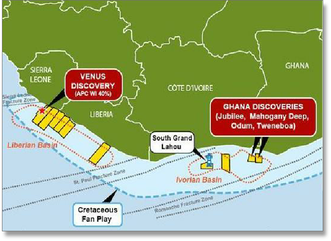
SIERRA LEONE: SEDIMENTARY BASINS
Globalshift.co.uk (source: Anadarko)