
Some of the numbers presented in this website may not be the most recent available
globalshift.co.uk - copyright © 2009 to 2026; All rights reserved


WEST AFRICA
West African coastline
Brief history of the country
Liberia (the Republic of Liberia) is bordered by Sierra Leone (west), Guinea (northeast) and Côte d'Ivoire (east). The Gulf of Guinea of the Atlantic Ocean runs along the southeastern coastline.
Records of people in Liberia go back to the 12th century when Mende people moved west from Sudan forcing smaller groups to the coast, especially as the Mali Empire collapsed. Tribes traded along the coast and slave-trading Arabs also arrived. From 1461 Europeans developed trading posts, naming the area the Pepper Coast, and then the Grain Coast.
In 1822 the American Colonization Society began sending thousands of freed black Americans to settlements in Liberia. The new arrivals believed in western politics and subjugated the indigenous tribes. Never colonised by Europeans, they declared independence in 1847 as Africa's first republic.
However, lack of investment and loss of territory to neighbours caused the economy to struggle. In World War 2 Liberia supported the USA who invested in infrastructure. The country grew strongly until a military coup in 1980 by the Krahn tribe. Two civil wars then devastated the economy.
Recovery only began after a peace agreement in 2003. The country remains poor and was hit by the Ebola epidemic from 2013 to 2015.
Oil and gas summary
Liberia comprises flat to rolling coastal plains that contain mangroves and swamps, which rise to a smooth plateau and low mountains in the northeast. Rainforests cover the hills, while grassy savannah and deciduous forests cover the north.
The highest point (entirely within Liberia) is Mount Wuteve at 1,440m in the northwestern Liberia range of the West Africa Mountains and the Guinea Highlands.
When the Atlantic opened rivers from the interior (St. Paul, Cestos, Cavalla and Lofa) flowed to the Liberian coast depositing a thick series of sediments into the Liberian basin.
The Harper Basin lies in the southeast offshore sandwiched between the Liberian and Ivorian Basins within the St. Paul Transform System. Syn-rift structural traps are present with analogues to producing fields in neighbouring basins. Regional channel and fan complexes have been mapped in the Upper Cretaceous and across the shelf, slope and into the deep basin.
Hydrocarbon exploration began offshore in the Liberia basin in the 1940s without success and by 2011 only 8 wells had been drilled. In 2000 seismic data was acquired in deep waters and drilling began in 2011 targeted at the Cretaceous fan play along the West African transform margin similar to the oil-bearing reservoirs in Ghana and Sierra Leone.
The geological potential of the deep water acreage leads Globalshift to forecast future oil, followed by gas production and rapid growth with output expected to begin in the late 2020s.
West Africa


LIBERIA
Map and National Flag

Capital
Population
Land area (sq kms)
Oil prod (000s b/d)
Gas prod (bcm/yr)
Oil cons (000s b/d)
Gas cons (bcm/yr)
Monrovia
4 mm
111,369
None
None
4
None
Government
The government of Liberia is modelled on the government of the USA. It is a unitary constitutional republic and representative democracy. The president is head of government, head of state and the commander-in-chief of the Armed Forces, elected to a 6-year term.
The Legislature is bicameral composed of the 30-member Senate serving 9-year terms and the 73-member House of Representatives.
The oil and gas industry is overseen by the Ministry of Commerce and Industry through the Liberia Petroleum Regulatory Authority (LPRA) and the National Oil Company of Liberia (NOCAL). The latter was established in 2000 for the purpose of holding all of the rights of Liberia in potential and proven reserves of oil and gas.
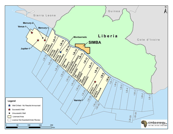
LIBERIA: OFFSHORE BLOCKS
Globalshift.co.uk (source: Simba Energy)