Some of the numbers presented in this website may not be the most recent available
globalshift.co.uk - copyright © 2009 to 2026; All rights reserved


Brief history of the country
Peru (the Republic of Peru) is bordered by Ecuador and Colombia (north), Brazil (east), Bolivia and Chile (south), and the Pacific Ocean (west).
Settlements, present in Peru before 9,000 BC, had led to civilizations appearing along the coast by 3,000 BC. These evolved into the Inca Empire by the 15th century which controlled most of the Andes. In 1532 the Spanish began to conquer the Incas, creating the Viceroyalty of Peru and completely subjugating them by 1572.
Peru became a rich centre for trade but declining revenues by 1776 forced its contraction with the loss of New Granada and Rio de la Plata. Peru then remained a royalist stronghold until independence from Spain in 1821, completed in 1824.
In 1879 under economic pressure, it entered and lost the War of the Pacific with Bolivia against Chile and ceded southern territories.
Since the 1900s the country has been generally peaceful with periods of strong economic growth, although subject to a series of coups, ranging from dictatorial to democratic systems. The country also fought territorial wars with Colombia and several with Ecuador.
Corruption led to the rise of rebel groups such as Shining Path, but since 2000 democratic progress has been achieved. Peru’s main economic activities include mining, manufacturing, agriculture and fishing.
Oil and gas summary
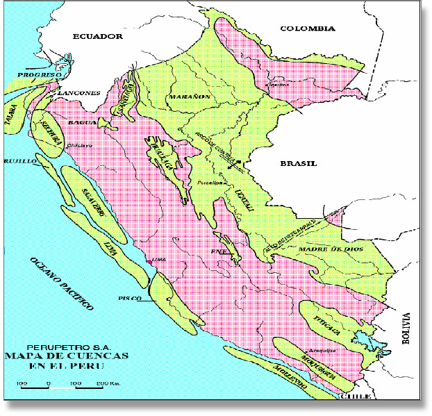
The Andes mountains runs parallel to the Pacific Ocean and defines 3 geographic regions in Peru.
The coast is a narrow arid plain cut by valleys. The Andean highlands (sierra) includes the Altiplano plateau and the highest peak Huascarán at 6,768m. East of the Andes is an expanse of flat terrain covered by the Amazon rainforest.
The first oil was produced in 1869 from the Talara Basin in the northeast near the coast. Although the area is still productive from a large number of fields, most oil now is piped from inland areas in the foothills east of the Andes along the border with Ecuador. This is known as the Oriente region. The Transandean Pipeline was opened in 1977.
Peruvian oil output was declining steeply since 1982 from the aging fields in both regions but recovered as heavy oils, condensates and especially NGLs associated with gas were developed.
Peruvian gas production increased rapidly as a result of the development of the giant Camisea complex, which came onstream in 2004 in the southeast of the Oriente Basin. Besides for local use, gas is supplied to an LNG complex on the Pacific coast 200 kms south of Lima that began exporting in 2010.
Offshore in the shallow waters of the Pacific Ocean small amounts of oil are produced from an extension of the Talara basin. Further offshore the continental margin is underlain by the Peru-Chile trench, where the Nazca Plate converges obliquely and subducts beneath the South American Plate. It is an accretionary prism, comprising Mesozoic and Cenozoic fore-arc basins that form the continental slope. The basins are separated by rotated basement highs, generated by strike-slip faulting. Intermittent reactivation of the basement faults led to extension and inversion during the Cenozoic providing a range of structural and stratigraphic traps. However, Globalshift recognises no significant oil and gas potential.

PERU
Map and National Flag

SOUTH AMERICA
Houses on a hill
South America


Capital
Population
Land area (sq kms)
Oil prod (000s b/d)
Gas prod (bcm/yr)
Oil cons (000s b/d)
Gas cons (bcm/yr)
Lima
29 mm
1,285,216
131
12
210
7
Government
Peru is a presidential representative democratic republic with a multi-party system.
The President is the head of state and of the government elected for 5 years.
The President appoints the Prime Minister and the Council of Ministers. Congress is unicameral with 130 members also elected for 5-year terms.
The Ministry of Energy and Mines sets policy for the exploitation of oil and gas resources in the country.
Perupetro, established in 1993, is the State company responsible for contracts. It promotes exploration investment, negotiates, execute and monitors contracts, manages data and oversees and regulates operations of contractors.
PERU: SEDIMENTARY BASINS
Globalshift.co.uk (source: Investor Village)