
Some of the numbers presented in this website may not be the most recent available
globalshift.co.uk - copyright © 2009 to 2026; All rights reserved


S. AND E. AFRICA
Boat on river
Brief history of the country
South Sudan (the Republic of South Sudan) is bordered by Sudan (north), Ethiopia (east), Kenya, Uganda and Congo-Kinshasa (south), and the Central African Republic (west). It is land-locked.
South Sudan was inhabited from around 5000 BC by Nilotic people who evolved, with inward migration, into tribes including the Dinka, Nuer and Azande. Several kingdoms ruled until 1821 when much of Sudan was occupied by Egypt, under the Ottomans.
Natural barriers and missionaries prevented the spread of Islam in the south with the Azande maintaining independence until the 1870s. Egypt established the province of Equatoria in the far south until 1885 when the Islamist Mahdi (Ansar) people took control.
After the indigenous Sudanese were subdued by the UK in 1898, South Sudan was run separately until 1956 when the UK and Egypt accepted an independent, united Sudan.
Lack of investment in the south of Sudan led to devastating civil wars. An autonomous region was then formed in 1972 until 1983 and a second civil war ended in a peace agreement in 2006.
South Sudan gained independence in 2011 but sporadic fighting continues along the border and internal unrest persists. Around three-quarters of former Sudan’s oil lies in South Sudan but the economy still relies on subsistence farming.
Oil and gas summary
South Sudan is land-locked and is covered in tropical forests and grassland. It also includes the swamp region of the Sudd (Bahr al Jabal) surrounding the White Nile.
The country separated peacefully in 2011 from Sudan (North), albeit after a protracted civil war. It took with it over three-quarters of the former country’s oil although there remains a dispute over the region of Abyei.
South Sudan began producing oil in 1993 from the Muglad Basin, part of the East African rift, near where it extends into North Sudan. New discoveries and developments led to increasing output from this region, followed by production from the rifted Melut Basin in 2005.
Globalshift predicts further unexplored potential remains in both basins.
Before the break-up oil was exported via pipeline through North Sudan to the Red Sea and now disagreements over pipeline tariffs has led to disruption of supplies. The country urgently needs a new outlet, through Uganda and Kenya, or Ethiopia and Djibouti.
South Sudan produces no marketed gas.
South and East Africa


SOUTH SUDAN
Map and National Flag


Capital
Population
Land area (sq kms)
Oil prod (000s b/d)
Gas prod (bcm/yr)
Oil cons (000s b/d)
Gas cons (bcm/yr)
Juba
8.6 mm
619,745
170
None
12
None
Government
South Sudan was an autonomous region of the Republic of Sudan from 2005 and independent, after a referendum, in 2011.
The Government of Southern Sudan was established and a constitution was adopted in 2005. However,sporadic fighting amongst several factions of government has resulted in unstable administrations.
The authoritarian head of state is the president who appoints a vice-president. A 170-seat National Legislative Assembly is the lower house.
The Ministry of Petroleum (MOP) oversees the oil and gas industry. It is entrusted under the Constitution with the management of all aspects of national petroleum and mineral wealth, from exploration and extraction to transport and sales. The state oil company is Nilepet.
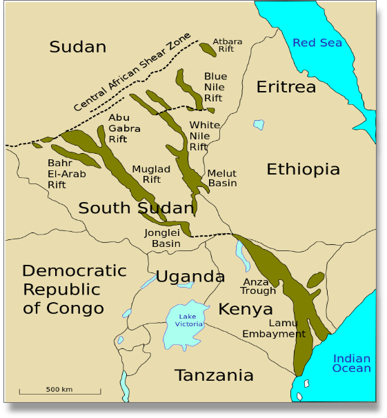
SOUTH SUDAN: SEDIMENTARY BASINS
Globalshift.co.uk (source: Wikipedia-Aymatth2)