
Some of the numbers presented in this website may not be the most recent available
globalshift.co.uk - copyright © 2009 to 2026; All rights reserved


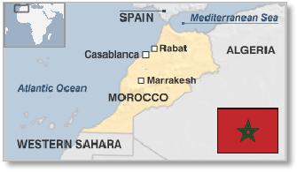
MOROCCO
Atlas Mountains
Brief history of the country
Morocco (the Kingdom of Morocco) has an Atlantic (west) and Mediterranean (north) coastline. It also borders Algeria (east) and Western Sahara (south) and has internal borders with two Spanish enclaves (Ceuta and Melilla).
Phoenicians and Carthaginians settled in Morocco after 600 BC before the Berber kingdom of Mauretania was created in the north. Rome took control in 33 BC although inland Berbers remained independent. When Rome fell the region was invaded by the East Germanic Vandals until Arabs arrived in 670 AD, establishing a series of Muslim states.
From 1062 the Berber Almoravids dominated both Morocco and Iberia until 1492 when the Reconquista ended Muslim rule in Spain. Reunited by the Alaouite Dynasty in 1666, the country survived Spanish and Ottoman invasions.
After 1830 France and Spain vied for control. In 1884 Spain created a coastal protectorate and in 1912 other areas became protectorates of France. Berbers tried to establish an inland republic (Rif) in 1921 with independence movements beginning again in 1943.
Independence was achieved in 1956 although Spain retained the two enclaves of Ceuta and Melilla. Morocco annexed Western Sahara in 1975 leading to a guerrilla war until a cease-fire in 1991. Peace processes have failed to break the deadlock. Morocco is stable but suffers occasional terrorist attacks.
Oil and gas summary
Morocco has a rugged mountainous interior and large desert regions. The Atlas Mountains run down the country from the northeast to the south west whilst the Rif Mountains are in the north bordering the Mediterranean from the northwest to the northeast. Most of the southeast is in the Sahara Desert.
Spanish territory comprises 5 enclaves on the Mediterranean coast: Ceuta, Melilla, Peñón de Vélez de la Gomera, Peñón de Alhucemas, the Chafarinas islands, and the disputed islet of Perejil. Off the Atlantic coast the Canary Islands belong to Spain, whereas Madeira to the north is Portuguese. Morocco claims that Western Sahara is part of its territory and refers to it as its Southern Provinces.
Small amounts of oil have been produced onshore from the Essaouira and Rharb basins since 1932 however, significant discoveries have never been made in Morocco despite a series of exploration campaigns, both onshore and offshore. Exploration continues, including in deep waters, but only limited additional potential is forecast.
Some gas production has been achieved onshore, especially in the Rharb Basin and a small gas field, Anchois discovered in 2009, may be developed offshore.
Gas shales are also present in the country and could add to gas production. Although growth is forecast by Globalshift, total output is unlikely to reach substantial levels.
Morocco consumes some gas, mostly imported from Algeria, and has a market able to absorb any growth in indigenous production.
North and Northwest Africa


MOROCCO
Map and National Flag


Capital
Population
Land area (sq kms)
Oil prod (000s b/d)
Gas prod (bcm/yr)
Oil cons (000s b/d)
Gas cons (bcm/yr)
Rabat
32 mm
446,550
0.6
0.25
210
1.25
Government
Morocco is an authoritarian regime with a constitutional monarchy and an elected parliament. The King holds executive and legislative powers over the military, foreign policy and religious affairs. Parliament, whose power is limited, is bicameral.
The Assembly of Representatives (Majlis an-Nuwwâb) has 325 members elected for a 5-year term. The Assembly of Councillors (Majlis al-Mustasharin) has 270 members elected for a 9-year term.
The oil and gas industry is overseen by the Ministry of Energy, Mining, Water and the Environment. The Office National des Hydrocarbures et des Mines (ONHYM) is the NOC representing the interests of the kingdom and partnering foreign companies in exploration and production programs.

MOROCCO: TECTONIC ELEMENTS
Globalshift.co.uk (source: ResearchGate)