
Some of the numbers presented in this website may not be the most recent available
globalshift.co.uk - copyright © 2009 to 2026; All rights reserved


Oil and gas summary
The border between Bosnia and Herzegovina, on the Balkan Peninsula, is only vaguely defined. Bosnia occupies the northern four-fifths of the country, while Herzegovina covers the remainder. The country is mostly mountainous, encompassing the central Dinaric Alps with its narrow sediment filled valleys. Northeastern parts extend into the edge of the Pannonian basin.
Over 50 onshore exploration wells were drilled in the Bosnian republic when it was part of Yugoslavia mostly in the 1950s and in the northeast within the southern extremes of the Pannonian Basin.
No commercial discoveries have been made although some wells may have intermittently produced a few barrels per day.
Two larger oil fields were reported to have been discovered in 2004; the Samac field in Republika Srpska and the nearby Tuzla field in the Federation. Both are located in the Pannonian Basin near the border with Serbia but little information is available and no forecasts for these have been made by Globalshift.
The largely mountainous country has no identified commercial oil or gas resources, onshore or offshore and Globalshift believes it is unlikely to achieve any production. No wells have ever been drilled in the very small offshore sector.

BOSNIA AND HERZEGOVINA
Map and National Flag


SOUTHERN EUROPE
Fishing scene
Southern Europe


Brief history of the country
Bosnia and Herzegovina comprise 2 autonomous regions (the Federation of Bosnia and Herzegovina, and Republika Srpska). A 3rd region (Brcko District) is locally governed. It is bordered by Croatia to the north and west, Serbia to the east and Montenegro to the southeast. Its Adriatic coastline is just 20 kms long.
At the end of Roman rule the region changed hands a number of times until it achieved self-rule in 1377. However, the kingdom was dissolved in 1463 when the Ottomans took over. The Ottomans acted to preserve Bosnia's Muslim identity and a Slavic Muslim group (Bosniaks) emerged in the west.
Rebellions against the Ottomans eventually led to the Treaty of Berlin in 1878 and Austro-Hungarian rule. Assassination of the heir to the Austro-Hungarian throne in Sarajevo sparked World War 1 in 1914.
In 1918 the country joined Yugoslavia in a federation of Serbs, Croats and Slovenes. During World War 2 it was ruled by Nazis in Croatia and Bosniaks were persecuted by Serb nationalists. The country was re-established as one of 6 republics of Yugoslavia in 1945.
Declaring independence in 1992, the Bosnian War broke out as Serbs (Republika Srpska in East Herzegovina) vied for power with Croats and Bosniaks (the Federation). In 1995 signing of the Dayton Agreement with Croatia and Serbia finally brought fighting to an end. The country’s economy has grown rapidly since then.


Capital
Population
Land area (sq kms)
Oil prod (000s b/d)
Gas prod (bcm/yr)
Oil cons (000s b/d)
Gas cons (bcm/yr)
Sarajevo
3.8 mm
51,197
None
None
29.5
0.25
Government
Government is complex with many layers. At the top the Presidency rotates among Bosniak, Serb and Croat members. A Council of Ministers is nominated by the Presidency.
The country splits into 2 autonomous regions established by the Daytona Agreement of 1995. They are run by Bosniaks/Croats (Federation of Bosnia and Herzegovina) in the west and centre where the Federal Ministry of Energy, Mining and Industry (FMERI) is the authority with responsibility for licensing, exploration, development and production of hydrocarbons.
In the east and north the Serbs (Republika Srpska) are in power.
The state government cedes numerous powers to these entities however recently many new central institutions have been established although each region has a right to use natural resources without consulting the other.
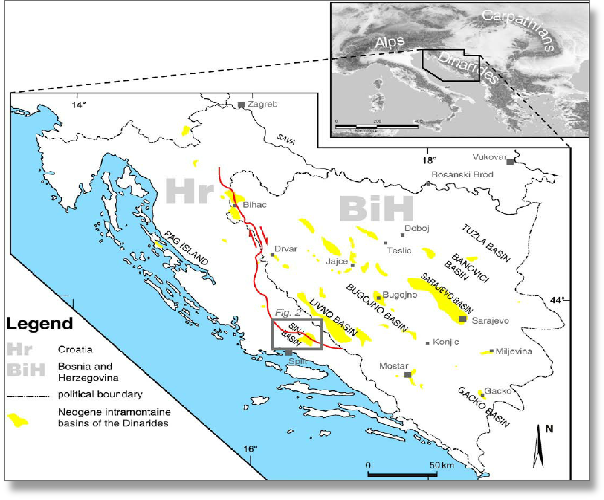
BOSNIA AND HERZEGOVINA: SEDIMENTARY BASINS
Globalshift.co.uk (source: Research Gate)
Geology and History of Exploration
Bosnia and Herzegovina encompasses the central Dinaric Alps (Dinarides), with its narrow intra-montane basins, and the northeast region which extends into the southern edge of the Pannonian basin. The country can be divided into 3 structural areas; the external Dinarides,the internal Dinarides and the Pannonian Basin.
The Dinarides - like the Albanides, Hellenides and Taurides, result from collision of the Adriatic and European plates from the Late Cretaceous to early Paleogene and subsequent deformation of the Adriatic margin. This tectonic activity formed a NW-SE-elongated SW vergent thrusted belt.
Sediments comprise a thick, deformed succession ranging in age from Carboniferous to Quaternary, including the Adriatic-Dinaric Carbonate platform (External Dinarides) in the southwest, the Bosnian Flysch, the Dinaride Ophiolite Zone, the Sava-Vardar Zone and finally in the northeast, allochtonous Paleozoic-Triassic units.
Source rocks are potentially Upper Jurassic to Cretaceous shales within Ravni Kotari evaporites. Oil shales are present in small Upper Cretaceous Basins. The Adriatic Carbonate Platform contains limestone and dolomites sealed by Paleogene Flysch which can act as reservoirs. Traps are linked to thrusted anticlines and drag folds. Numerous oil seeps have been identified in the region with movement during the Miocene probably breaching older accumulations.
The Pannonian Basin - overlies the southern edge of the Pannonian Basin, where extension since the Neogene has created deep depressions containing potential source and reservoir rocks, in particular in the Tuzla Depression.
The most important source rock is of Badenian age whilst reservoirs are interbedded coarser clastics and pre-Neogene fractured basement. The seal can be Pliocene marls and shales in structural and stratigraphic traps on the edges of horsts and grabens although faults may or may not provide effective seals.
Very small volumes of oil have been extracted from a limited number of wells either within the narrow intra-montane sedimentary basins or on the edge of the Pannonian Basin near the border with Serbia. However, Globalshift believes both areas have no significant oil and gas potential, either onshore or in the very small offshore sector of the Adriatic Sea.
History - Oil and gas exploration began in 1889 when Austrian geologists Katzer and Hofer began exploring the Majevica area. Over 50 onshore exploration wells were drilled mostly in the 1950s in the Bosnian republic when it was part of Yugoslavia. Many of these were in the northeast along the edge of the Pannonian Basin where it is known as the Tuzla Basin.
No commercial discoveries were made although some wells such as Bijeljina-1, Obudovac-1 and Brvnik-1, intermittently produced a few barrels per day for local use.
In the 1990’s INA was the main operator exploring near Tuzla and in the central and external Dinarides. The war then stopped activity until the late 2000’s when drilling restarted. Two larger oil fields were reported to have been discovered in 2004; the Samac field in Republika Srpska and the nearby Tuzla field in the Federation. Both are located in the Tuzla Basin near the border with Serbia.
In 2013 Shell was looking at a large concession offered by the Federation of Bosnia and Herzegovina in the Dinarides but pulled out. Total also expressed interest but pulled out in 2016.