
Some of the numbers presented in this website may not be the most recent available
globalshift.co.uk - copyright © 2009 to 2026; All rights reserved


Brief history of the country
Belize is a Central American and Caribbean nation bordered on the north by Mexico, on the south and west by Guatemala, and on the east by the Caribbean Sea. English is the official language.
Farm settlements had existed for 1000 years before Mayans migrated to Belize in 1500 BC, dominating until 900 AD. The Spanish arrived in the 16th century but chose not to settle. British settlers then arrived in the 17th century. Repelling Spain, they established a logwood-trading colony using slaves.
In the 19th century the UK demanded the settlers end all slavery although former slaves continued to work in timber cutting. In 1836 the UK claimed administration rights and in 1862 it was declared a Crown Colony and named British Honduras.
Belize was reliant on the mahogany trade until 1930 when demand for timber declined. Economic conditions improved in World War 2 (as Belizean men joined the armed forces) but worsened after the war.
The country demanded independence and was granted self-government in 1964 and in 1973 renamed Belize. However, full Independence was not achieved until 1981, slowed by a Guatemalan claim to sovereignty. Guatemala finally recognised it in 1991 although border disputes continue.
Belize has a small, enterprise economy with sugar and bananas key crops.
Oil and gas summary
Belize flanks the Caribbean Sea where the second-longest barrier reef in the world runs along its marshy coastline with many lagoons.
Two rivers, the Hondo and the Sarstoon, define the northern and southern boundaries respectively whilst the western border runs north-south through lowland forest and highland plateau. The north consists of flat, swampy coastal plains, in places heavily forested. The south contains the Maya Mountains, the highest point being Doyle's Delight at 1,124m.
The country began producing oil from the Spanish Lookout and Never Delay fields in 2005 that lie on the eastern edge of the Peten basin very close to the Guatemalan border. The fields lie due east of Guatemala’s largest oil field, the Xan field, and northwest of Belmopan, Belize’s capital.
Production flows from two Cretaceous zones, the Yalbac and Hill Bank formations, and both are believed to have equivalents in the producing Coban formation in Guatemala.
However, since these discoveries there has been scant further success and the limited size of the productive area suggests to Globalshift that there is little chance for significant oil production increases in the future. No gas is produced or consumed in Belize.
There is no offshore production in the country and only a few wells have been drilled. Offshore drilling is now banned on the reef and offshore discoveries are not forecast by Globalshift in the country.

BELIZE
Map and National Flag


CENTRAL AMERICA
Stormy seas
Central America


Capital
Population
Land area (sq kms)
Oil prod (000s b/d)
Gas prod (bcm/yr)
Oil cons (000s b/d)
Gas cons (bcm/yr)
Belmopan
0.34 mm
22,966
2.6
None
4.9
None
Government
Belize is a parliamentary monarchy based on the British system. The head of state is the UK monarch represented by the Governor-General.
Executive authority is exercised by the cabinet, which advises the Governor-General and is led by the Prime Minister who is head of government.
The bicameral National Assembly of Belize is composed of a 31-member elected House of Representatives and a 12-member appointed Senate.
The Ministry of Energy, Science & Technology and Public Utilities (MESTPU) is responsible for oil resources.
The Geology and Petroleum Department of this Ministry oversees the petroleum industry and supervises and monitors operations.
Belize Natural Energy (BNE) is a local private company and the only oil producer in the country.
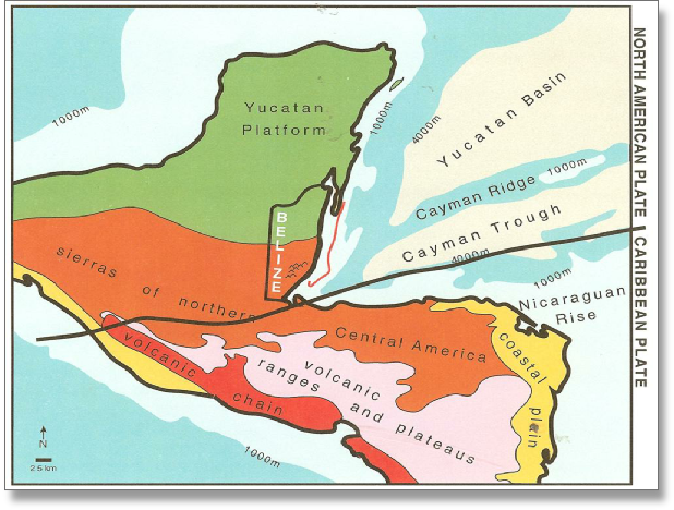
BELIZE: TECTONIC SETTING
Globalshift.co.uk (source: ambergriscaye.com)
History of Exploration
Petroleum exploration in Belize (then British Honduras) began in the 1930’s when licenses were granted to a number of oil companies including Shell, Esso, Texaco, Gulf Oil, Anschutz and Chevron covering both onshore and offshore areas.
The first exploration well, Yalbac-1, was drilled by Gulf Oil in the Yalbac Hills in the Cayo District in 1956. Seismic surveys were also run offshore and onshore. By the year 2000 around 50 exploration wells had been drilled (34, onshore and 16, offshore). However, all were dry or had only minor oil shows.
The most significant was the Eagle-1 well drilled in 1984 in Belmopan, which recovered around 3 bbls of light oil when production tested. The last well drilled during this period was Gladden-1 by the Dover Consortium in 1997 in the Glovers Reef area.
tIn 2000 an oil seep was discovered at a depth of 40m in a water well drilled at Calla Creek in the Cayo District. Subsequently an exploration license was granted to Belize Natural Energy (BNE) which made the first commercial discovery of light oil in 2005 at Spanish Lookout in the Mike Usher-1 well.
BNE developed it as the Spanish Lookout field in 2005 and later made another commercial discovery of light oil in 2008 in the Never Delay-1 well. This became the Never Delay oil field. Oils from both fields are trucked to an export facility at Big Creek and shipped and sold in the USA.
Oil output has declined rapidly since Spanish Lookout went onstream. Although some stabilisation and recovery may occur, production is unlikely to reach again the peak output of a little over 4,000 bbls per day established in 2010. Drilling levels are also expected to remain low.
No gas production is forecast by Globalshift for Belize and the ban on offshore drilling (to protect the coral reef) precludes any potential output from offshore waters.
BNE is the only producer of oil in Belize. However, a number of companies have held exploration licenses which occasionally carry out seismic surveys and drill exploration wells.