Some of the numbers presented in this website may not be the most recent available
globalshift.co.uk - copyright © 2009 to 2026; All rights reserved


WEST AFRICA
Beach scene
Brief history of the country
Angola (the Republic of Angola) borders Namibia (south), Congo-Kinshasa (north), Zambia (east) and the Atlantic (west). The semi-exclave of Cabinda borders Congo-Brazzaville and Congo-Kinshasa.
Hunter-gatherers were replaced by Bantus from the north around 500 BC who established a number of trading kingdoms, including Kongo in the northwest and Ndongo in the south. In 1484 Portugal established a colony at Soyo followed by other settlements along the coast, trading in slaves for Brazil.
Luanda was founded in 1575 (occupied by the Dutch from 1641 to 1648) but Portugal did not colonise inland. From 1885 settlers began to explore the interior but full Portuguese control and fixed borders were only established in the early 20th century.
Nationalists appeared in the 1950s provoking the Colonial War in 1961 and Angola finally gained independence in 1975 after a coup in Portugal in 1974. The 3 nationalist movements began a long civil war which was a flash point for the global ‘Cold War’.
Cuba supported the socialists and most Portuguese colonialists fled the country. The war lasted until a peace accord in 2002 but separatist unrest has continued in Cabinda. Angola is now relatively stable with its mineral and petroleum reserves and a fast-growing economy. There remains a large gap between rich and poor.
Oil and gas summary
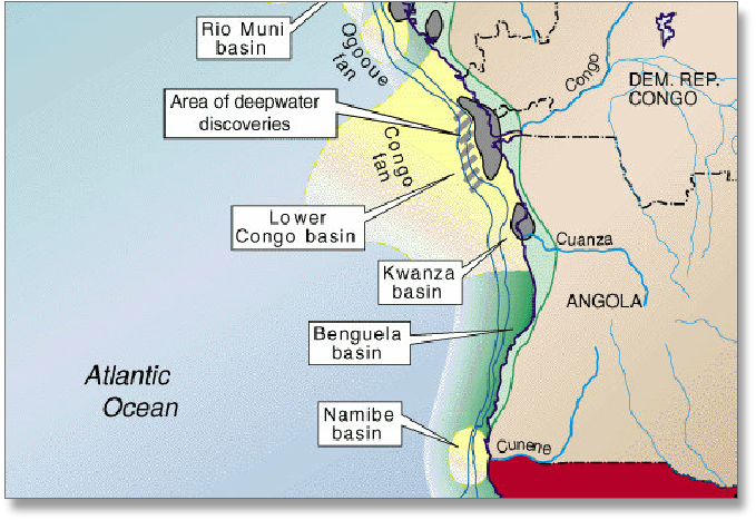
Angola comprises an infertile coastal plain extending inland for up to 150 kms. Further Inland, and parallel to the coast, is a belt of hills and mountains behind which is a large plateau.
The geology and outline of the west coast of Angola was created during the opening of the South Atlantic Ocean from the Early Cretaceous until the Eocene. The central plateau is thus a Paleozoic basement block whilst the coastal zone is covered by a Tertiary and Cretaceous basin section with recent basalt extrusions forming a line of hills.
Angolan onshore oil production began in 1955 from the Kwanza Basin near the coast. Offshore production, began in 1967 from the Congo Basin off north Angola including the area offshore of the semi-exclave of Cabinda.
Production from shallow waters was declining when deep water fields went onstream firstly from the Girassol field in 2001 and Angola became a major exporter. A large number of fields in deep and ultra-deep waters are now producing whilst new sub-salt plays are also being discovered.
Meanwhile associated gas production had been flared or re-injected but an LNG plant in Soyo came onstream in 2013, tapping a large number of fields. This has led to growing marketed production levels. The plant had many teething problems but by 2016 output had stabilised.

ANGOLA
Map and National Flag
West Africa


Capital
Population
Land area (sq kms)
Oil prod (000s b/d)
Gas prod (bcm/yr)
Oil cons (000s b/d)
Gas cons (bcm/yr)
Luanda
30.2 mm
1,246,700
1,324
9
120
2.9
Government
Angola has an authoritarian regime with political power concentrated in the presidency. The executive government is composed of the President, the Vice-Presidents and the Council of Ministers.
There is also a 220-seat unicameral legislature elected from provincial and nationwide constituencies.
The oil and gas industry was overseen by the Ministry of Energy and Water. Sonangol is the state-owned company. It administered petroleum and gas production but was replaced by the Agência Nacional de Petróleo, Gás e Biocombustíveis (ANPG) in 2019.
Sonangol was nationalised in 1976 from ANGOL (founded in 1953 as a subsidiary of Portuguese company SACOR).
Sonangol now has over 30 subsidiaries and is a major shareholder of the Portuguese company, Galp Energia.
Angola was a member of OPEC since 2007 bit withdrew in late 2023.
ANGOLA: SEDIMENTARY BASINS
Globalshift.co.uk (source: Oil and Gas Journal)